


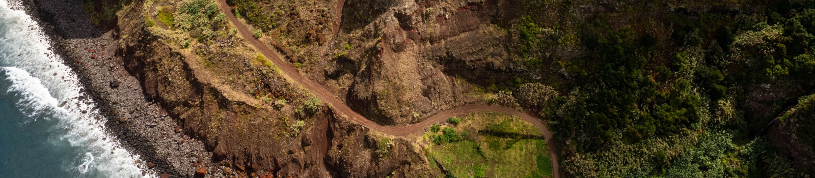
- Population growth, infrastructure expansion and increasing forestry and agricultural activities in mountain areas, besides the lack of control and slope reinforcement works, increase the probability of landslides during the occurrence of triggering events such as rainfalls or earthquakes.
- On other hand, the forecasts suggesting an increased in heavy rain events, deforestation and forest fires, are factors that increase the likelihood of landslides, as well as their intensity.
- Besides strongly affecting the population, landslides can cause great damage at environmental level, to name the destruction of forest and agricultural resources, removal of the fertile soil layer which in turn reduces land productivity, rivers blockade and increased danger of mass movements.
- Resulting maps from landslide risk assessment can be used to delimit zones where risk cannot be mitigated and those where population relocation plans should be designed.
- CAPRA module for landslide hazard assessment Landslide Hazard Mapper.
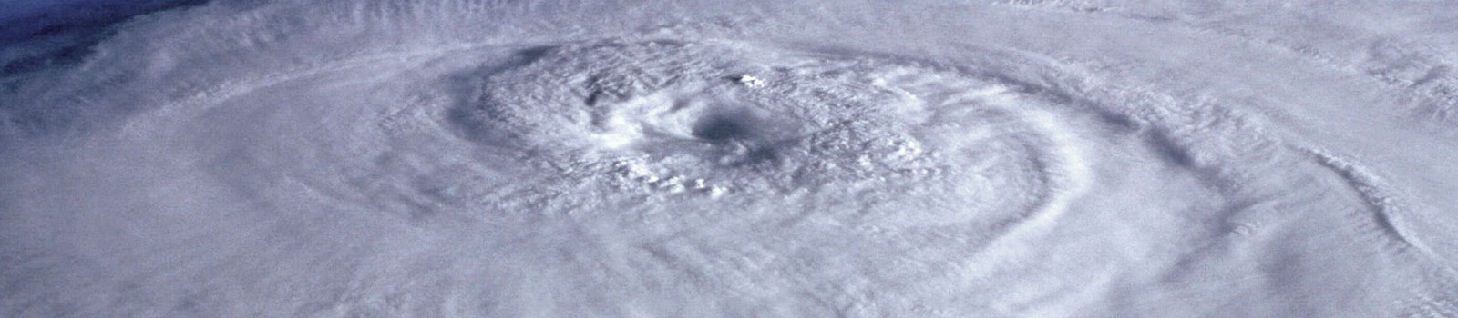
- Damages associated to high intensity hurricanes are usually devastating.
- When a hurricane makes landfall, it can generate heavy swells that can rise up to 6 mt high, spreading throughout 160 km, being this the most damaging effect, since around 80% of hurricane victims die where these make landfall.
- Likewise, winds cause massive destruction and represent a great danger, especially for infrastructure. Heavy rains cause damages mainly for the events they can trigger, such as floods and landslides, that can occur several kilometers inland.
- Capra module for tropical cyclones hazard assessment TCHM.

- Heavy rains trigger events that can be catastrophic, such as floods, landslides or mass movements.
- Additionally, such processes together with others such as earthquakes, can generate extraordinary catastrophic situations.
- Floods associated to rivers overflowing are the costliest and more frequent natural hazard, affecting most of the countries worldwide constantly (UNISDR, 2011).
- Overflowing are a frequent and natural event for a river, as a result of heavy or constant rainfall. These events can reach catastrophic dimensions impacting human settlements, infrastructure along riverbanks, representing a great danger for the population living along rushing rivers.
- CAPRA module for flood hazard assessment Flood Analyst and convective rainfall Stochastic Rainfall Modeler.
- Agriculture and water use are inseparable linked; hence, droughts have direct impact on forest and agricultural production, mainly affecting producers.
- Likewise, drought events can have an impact on drinking water supply and even cause famines, thus severely affecting the sustainability of the involved communities, forcing them to migrate. Unlike other types of natural phenomena, droughts are events that can last long periods, causing then, a strong negative impact on development.
- Agricultural droughts occur when water content in soil doesn’t satisfy the crops’ water demand. Droughts are one of the most complex natural phenomena that affects a great amount of people around the world.
- Today there is an urgent need of strengthening the actions face to extreme climate events, since their impacts depend on the vulnerability and preparedness of the communities to respond and cope with these phenomena, factors that are in turn influenced by the socioeconomic conditions of the population.
- CAPRA module for drought risk assessment: Drought Pro.
- Earthquakes have proved, over the course of the history, being one of the natural hazards with highest levels of social and economic impact.
- The occurrence of major earthquakes that affect a city or population concentration zone is inextricably linked to major economic and human losses. The large losses generated by earthquakes mean a critical problem for development countries, especially for those where exposure in terms of informal buildings grows rapidly.
- Even though it is well known that seismicity is recurrent and also that low magnitude earthquakes are more frequent that those of high magnitude, it is not possible to estimate when and where the next earthquake will occur and neither its magnitude.
- The results of seismic hazard modelling allow us to predict the possible impacts of probable events in a given site, which make them a fundamental tool for land use, development and physical planning. Understand the hazard gives us tools to reduce risk.
- CAPRA module for seismic and tsunami hazard assessment R-CRISIS.

- Tsunamis are events of enormous destructive potential. A tsunami can travel thousands of miles and impact simultaneously the coast of different continents resulting in huge losses and damages.
- In total, 14 large tsunamis have caused 250.879 deaths in 22 countries between 1995 and 2016 (EM-DAT). Understanding the mechanism of generation and propagation of tsunamis serves for the drafting of early warning systems addressed to identify whether a seismic event is capable or not of generate a tsunami and how big it would be, as well as the development of risk mitigation strategies in coastal zones.
- Through probabilistic modelling it is possible to establish aproximations on future tsunami’s characteristics, that will serve as a basis for the desing of preventive action and emergency response plans, as well as warning systems in critical areas.
- CAPRA module for seismic and tsunami hazard assessment CRISIS2015.
- The fertile soils characteristic of the areas surrounding volcanos have always attracted settlers and therefore throughout the story large communities have developed in these zones. Nowadays, in 150 km of volcanoes’ surrounding areas there is an estimated population of a billion people.
- Eruptions such those from Armero (Colombia) in 1985, or the volcano Soufrière Hills in Monserrat in 1995, that destroyed the city of Plymouth, have demonstrated that the proximity of settlements to volcanoes represents a great risk for communities, besides being a threat to national economy. Nevertheless, since these eruptions are rare events, the risk that they represent is in some cases underestimated.
- Since the losses due to volcanic eruptions as well as the adverse effects on the population can be mitigated thanks to the study of volcanoes’ behavior, that allow in a certain way to forecast eruptions and thus program evacuations, volcanic hazard modelling has become an essential instrument for planning.
- CAPRA module for volcanic hazard assessment VHAST.
“Nowadays, in a 150 km of volcanoes’ surrounding areas there is an estimated population of a billion people.”